

Airborne Laser Scan (ALS) Standard Classifier
published: 11.11.2022
Do you regularly work with LiDAR and need an efficient solution for labelling your gathered data? Our ALS Standard Classifier is specifically trained to work with your aerial scanning data! Find out more about it in this blog post.
What is the ALS Standard Classifier?
While some of our Standard Classifiers are trained with a narrowed range of functions, such as detecting certain object classes, the ALS Standard Classifier is optimized for mapping and labelling point clouds gathered with aerial LiDAR technology. As such, the model is able to work efficiently with average point densities of 10 to 50 ppm² and includes intensity values.
What is ALS? What is aerial LiDAR?
Airborne Laser Scanning (ALS) and aerial LiDAR (Light Detection And Ranging) are often used synonymously. The terms describe a method of measuring distances by pinging the ground with lasers in regular intervals and gathering how long it takes for the signal to return to the aerial LiDAR scanner. The data collected through this remote sensing technique can also be used to create a detailed surface model.
How do I use the ALS Standard Classifier?
With the Airborne Laser Scan Classifier, you can effectively streamline your work with LiDAR data. Simply choose the classifier upon uploading your point cloud:
- Upload your LAS/LAZ file into Pointly
- Under “Select Classifier” you choose the Standard Classifier for Airborne Laser Scans
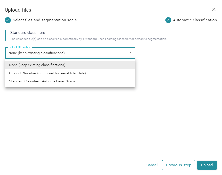
A selection of standard classifiers will pop up
3. Choose the option “Add model tag to the uploaded file(s)” to mark the point cloud with your chosen classifier for easy identification
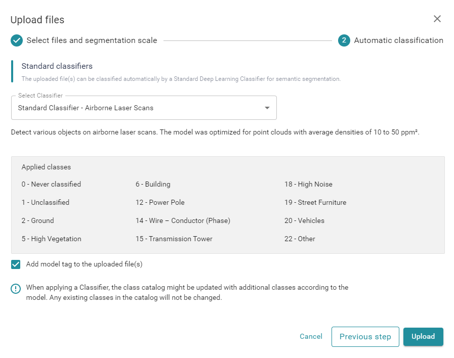
Adding model tags makes it easier to keep an overview where the initial classification came from
4. After clicking on Upload, your files will be automatically processed. The duration is depending on the number of points and can take from a few minutes up to 2 hours for very large point clouds (100+ MPoints).
Want to experience how much time can be saved by automating the labelling of your 3D-LiDAR model? Try it yourself right now with a Free Account or get in contact with us to convince yourself of Pointly’s efficiency.
Try all Standard Classifiers for free!
Already collected some ALS data? You can directly test our Standard Classifiers with your own scanning data. Using your Free Account you are able to work with up to 3 point clouds! If you want to display more than 15 million points and need to download the results, you can opt for a Professional Account.
What can the ALS Standard Classifier be used for?
Several industries make use Airborne LiDAR systems to create helpful point cloud models:
- Forestry
- Archeology
- Urban Planning
- Architecture & Building Information Modelling (BIM)
- & many more!

Benefit from quick and easy classification of your point clouds for your specific use case
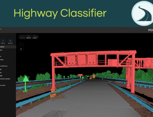
The ALS Standard Classifier is able to detect several classes, including:
- Ground
- Vegetation
- Buildings
- Vehicles
- Power lines
- Road inventory
Exemplary use case
Your business focuses on forestry and has gathered point cloud data with aerial LiDAR scans. By using the ALS Standard Classifier, you can automatically detect vegetation as well as differences in elevation of the ground. With the classifier being optimized for airborne laser scanning, you receive a 3D model which allows you to create an accurate inventory of vegetation seen from above. It is also excellent for precise change detection between two or more periods in time.
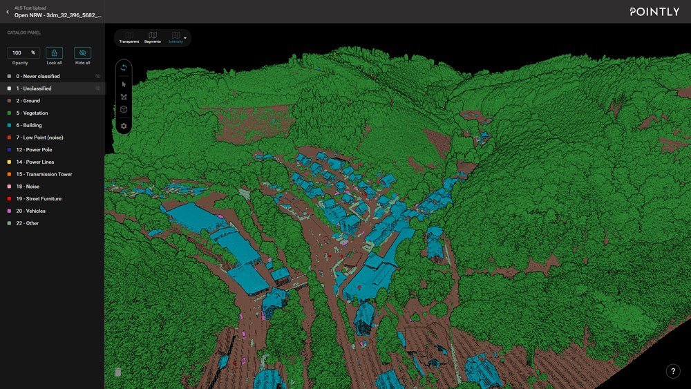
Each class is highlighted in a different color for easy differentiation
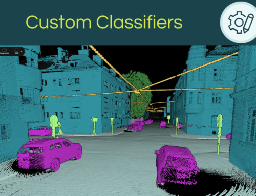
A classifier tailored towards your needs
The ALS Standard Classifier sounds promising but is lacking some features that are essential for your use case? Pointly also offers to train a Custom Classifier that is adapted to suit your very needs. We train it by improving on the Standard Classifier with an elaborated AI workflow, to detect different data types or custom object classes.
Curious to learn more about upcoming Pointly features? Subscribe to our newsletter and follow us on LinkedIn to learn about updates and more!
Pointly – Point out what matters.
Pointly is an intelligent, cloud-based software solution to manage and classify 3D point clouds – faster and more precise than ever before.
With Pointly Services you can get on-demand advanced 3D point cloud solutions tailormade for you.

how does the cost of using ALS Standard Classifier compare to other remote sensing techniques?