
POINTLY POINT CLOUD SERVICES
On-demand advanced 3D point cloud services
tailormade for you.
On-demand advanced 3D point cloud services tailormade for you.
Combine five single services into robust data pipelines or choose the one(s) you need. We offer you the best service along with your 3D AI project and help you to bring it to life!
Take advantage of years of experience of the Supper & Supper GmbH - the creators of Pointly - which develops customized AI solutions based on the latest developments in neural networks and machine learning.
If you have a custom use case in mind, you can inquire about a solution tailored to your needs through Pointly Point Cloud Services.
Pointly's Point Cloud Services.

Labeling
Flexibly order labeling tasks through our scalable and professional workforce partners and receive accurately classified results faster.

Custom Classifiers
Receive your own specific AI model for automatic point cloud classification. The custom classifier can be deployed on Pointly, used via API or as on-premise classification tool.

Object Detection
Automatically classify point clouds and detect object instances with powerful 3D AI algorithms.

Analysis
Unlock insights regarding distances, volumes, types, and more through automated pipelines.

Conversion
Receive outputs for the formats that work best for you, for example, map layers or CAD models.

Point Cloud Management System
Use Pointly to store and manage your point cloud data. As an enterprise solution with role-based access and an intuitive interface, Pointly is ideal for securely storing and managing your point clouds in an ISO-certified cloud environment.
Use Cases.
Services combined into robust and scalable AI pipelines.
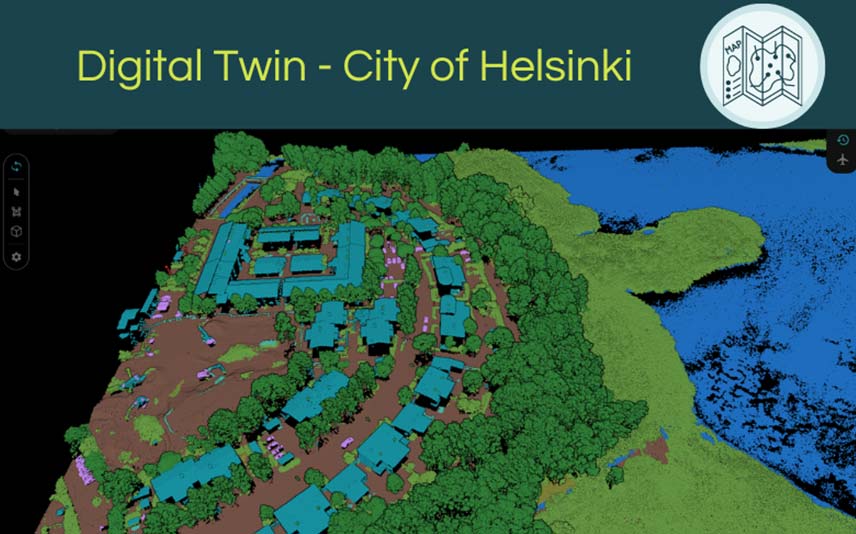
Find out how we took advantage of the transfer learning technique to optimize our Airborne Laser Scan Classifier to a dataset of the City of Helsinki. Thanks to our successful collaboration, they can now leverage their digital twin project to help digitize the whole city.
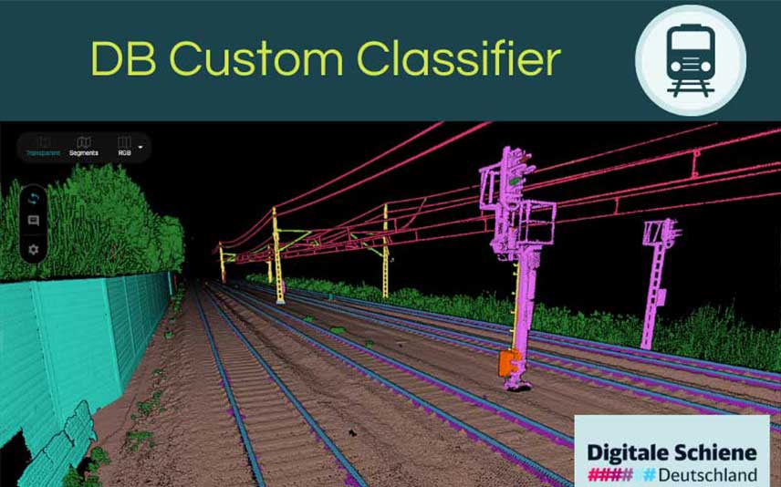
Learn about our successful collaboration with Digitale Schiene Deutschland: Automatic classification of assets along the railway infrastructure.
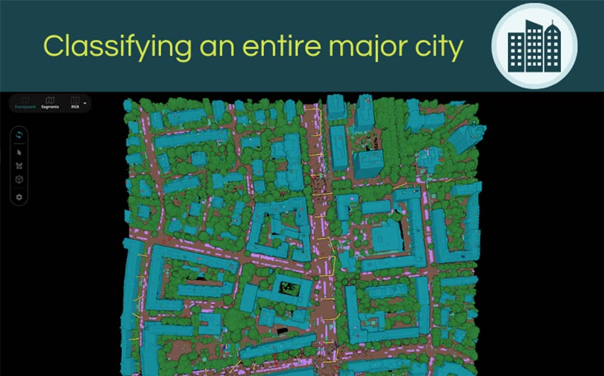
Have you ever wondered how scalable our Pointly platform is and if it’s possible to process an entire city? Thanks to this cooperation you will get a clear answer: Yes!

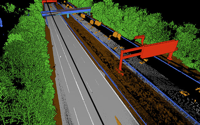
The automated generation of CAD models from 3D highway scans
The goal of this project was to automate the generation of CAD models from point clouds with the help of deep learning.
The automated labeling of point clouds from highway scans
The goal of this infrastructure project was to fully automate point cloud labeling by using deep learning models.

The new way of generating BIM models from 3D point clouds
We created a BIM Model from photogrammetric point clouds with added area attributes for roofs and walls.
Creating a street asset inventory from point clouds by using AI
The goal is to detect street assets in point clouds and classify street signs to precisely map them into a GIS system.

The automated conduction of a forest inventory
The goal was to provide exact tree point identification in the point cloud and individual tree separation with corresponding inventory data.

Labeling Services.
Do you need large amounts of point cloud data manually classified but would prefer to hire someone instead of processing it manually?
In collaboration with best in class Labeling Service Providers, we provide access to scalable and professional workforces that allow you to order labeling tasks flexibly. The project can either be managed by yourself, or we take over all the work and deliver the final dataset to you. Providing its labeling services, Pointly has already achieved high-precision in many projects.
Since the work will be done with Pointly’s intelligent selection tools, you can expect to see results much faster!

Custom Classifiers.
Are you looking for a way to make your point cloud classifications more efficient?
Then Pointly’s Custom Classifier Service is for you!

With this service, we offer you the possibility to benefit from automated classifications and tailor-made neural networks, specifically for your use case. This way you will profit from immense time savings over manual annotations and you can focus your work on the tasks that add the most value to your data.
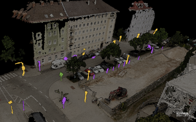
Detection Services.
Do you need your point clouds to be enriched with point classification information?
Automatic Point Cloud Classification
We can automatically classify the objects you want in your point clouds. Pointly first manually creates training data and then proceeds with creating an accurate automated pipeline for you. The main goal will be to develop standard detectors which you can use to classify complex point clouds way faster than before.

Every point that is a member of the “house” class can only be filtered with all other members of that class.

Every single instance can be adressed individually. For example, you can list all houses and pick them individually rather than one, all or none.
Automatic Instance Segmentation
We can automatically classify the objects you want in your point clouds. Pointly first manually creates training data and then proceeds with creating an accurate automated pipeline for you. The main goal will be to develop standard detectors which you can use to classify complex point clouds way faster than before.
Every point that is a member of the “house” class can only be filtered with all other members of that class.
Every single instance can be adressed individually. For example, you can list all houses and pick them individually rather than one, all or none.
Analysis.
Aggregate Analysis
Building on our Automatic Point Cloud Classification Service, you can quickly summarize and filter the information contained in a point cloud. This especially includes surface coverage and surface properties such as:
- Elevation (Ground and Surface)
- Height above Ground
- Footprints of Object Classes
Per-Object Analysis
Building on our Automatic Instance Segmentation Service for modeling and labeling, it becomes possible to extract information from your point clouds at the level of single objects. This includes, for example:
- Position
- Shape
- Lengt/Width/Height
- Area
- Volume
- Smallest Bounding Box
- Object Type

Conversion.
You can combine our analysis services with our conversion services, depending on what output format you would like to receive the analysis in.
Point clouds are only the start in an advanced 3D analysis pipeline. You can further refine the outputs of our robust Analysis Services, whether aggregated or per object, into other data formats that tie right in with existing workflows. That is why we offer the following point cloud conversion services:
CAD data
Being able to detect individual instances of object classes down to single building components, we are happy to offer you automatic point cloud data into CAD conversion services.
Vector data
Individual object footprints or positions are best represented as shape layers which you can then use in any GIS software. These formats also allow storing of additional features from our Analysis Services as per-object attributes.
Raster data
Surface properties such as elevation or type can be represented best as raster data, with formats such as GeoTiff, GeoJson, and more. This also includes aggregate statistics from our Analysis Services.
Tabular data
Do you prefer a straightforward summary of the objects in your point clouds? Then, based on our Instance Segmentation Service we can provide you with a detailed table of all individual objects, their types, and any required additional attributes such as volume.
Other
Do you want pdf reports, an interactive dashboard, or integration into a website? Contact us for custom inquiries, and we make sure to get the valuable information from your point clouds to where it is needed.
